
On
July 26-27 was my very first Mt. Apo climb using the Kapatagan Trail in Digos
City during the seminar conducted by Digos LGU to its aspiring guides and
porters relative to its impending trail reopening which I hope would happen
anytime this year. This move of Digos City somehow delighted me because it will
solve the problem of trail congestion in Sta. Cruz area. Last March Bansalan
Trail was also being opened for mountaineers. With this recent development the
opportunity for ecotourism in Mt. Apo is now being equally provided to its surrounding
localities, which also connotes identical chances for employment and
environmental conservation.

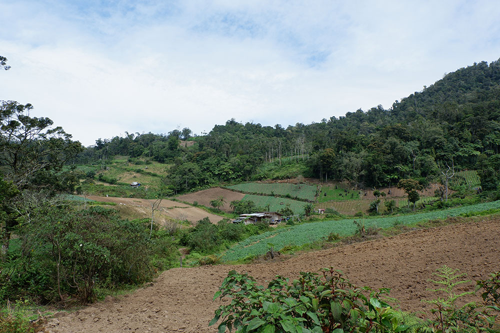
Although
the trails of Kapatagan and Sibulan share the same characteristics I personally
witnessed the fast depletion of forested area in Digos particularly in sitio
Paradise where farms of high-value vegetables encroached major portions of the
Strict Protection Zone (SPZ) of Mt. Apo. Plantations of potato, carrots, bell pepper,
cabbage and the likes have grown steadily in terms of land area. While we
recognize that high-value crops planting means resolving economic issue but the
lessening fragment of SPZ is also quite alarming. This predicament poses great
challenge to concerned national government agencies like the Department of
Environment and Natural Resources (DENR), National Commission for Indigenous
Peoples (NCIP) and even the Local Government Units (LGU).


Meanwhile,
the vast farmlands from sitio Mainit (trail head) until the emergency camp in
Upper Sabwag, which account for almost 60% of the entire trail, drained most of
us. It has been my perpetual weakness to trek in an open area with the heat of
the sun scorching. There are forest portions somewhere else along the way, but
it would always return back to farmlands, something a trail man would always hate
to see.


There
was a portion where locals call it “Sukarap” rest stop. The small shed here
provides shade to trekkers. There is also a water source in this part. As we
had some short chat with fellow mountaineers in Sukarap I saw plenty of White-breasted
Woodswallows gliding. On the other side following a short trail up northwest I
spotted one Black-and-Cinnamon Fantail and numbers of Rufous-fronted Tailorbird,
a specie endemic only in Mindanao island. Aspiring Kapatagan guides Arjay and Joel were able
to photograph a bird specie which I thought was either Magpie Robin or Pied
Triller, or to some extent might be a Pied Flycatcher. In between Baruring 2
and Godi-godi campsite I saw fresh bird feathers scattered, maybe serving prey
to slayer fauna.


The
flora species in Kapatagan trail are pretty much the same in Sibulan. Dominant
trees are made up of Tinikaran and some almaciga. Giant ferns and mosses in
tree branches are familiar sceneries. Wildflowers are anywhere else, in fact in
greater numbers than what I saw in Sibulan trail. Several fallen logs from
Upper Sabwag to Godi-godi campsite have made Kapatagan trail more exhausting.


Water
sources are readily available from the trail head to Godi-godi but the major
water source of the Kapatagan Trail is at the Baruring Rivers 1 and 2. Godi-godi
campsite has fewer water source available but we were told by locals that when
it rains the potable water there is sufficient enough to cater to large-group
camping.


For
more than a year that Kapatagan trail was closed the Godi-godi campsite serves
as home to a lot of mountain fauna, most notable of them are the monkeys
occupying a portion of the camp. At far south of the camp we saw a traditional
trap we believed was left by locals as a hunting mechanism with some remains of
monkeys as victims. Insects of different sounds were heard all over the place,
in fact I saw one of them there.


At
5:00 AM the following day we trekked to the boulders side of Kapatagan using
the ridge connecting Godi-godi to White Sand e-camp. The boulders here are
totally different as compared to Sta. Cruz side. Unlike in Sibulan where after
a trek from Tinikaran Camp 2 the sunrise can be visible, the sunrise spot in
Digos trail is covered by Baby Apo, allowing trekkers to hike further up near a
cliff of the largest sulfur deposit in Mt. Apo. The sulfur vent is the most prominent
identity in Digos trail, which at times can also be detrimental especially if
the smoke flows directly towards your direction. The 87-degree track is the
convergence point of Digos and Sta. Cruz trails which lead to the dead crater
lake and the Davao del Sur summit.


In all honesty I could only pray that the reopening of Kapatagan trail will be materialized this year to somehow provide alternative livelihood to its local guides and porters and at the same time minimize farming activities in sitio Paradise.
No comments:
Post a Comment