Saturday, June 24, 2017

Batuno-Sibulan-Tibolo Double Traverse

Official duties prompted me to lead a double traverse climb in the mountain ranges of Batuno, Sibulan and Tibolo together with other local stakeholders to scout for possible bridge projects that may connect small sitios in far-flung areas of Sta. Cruz. The presence of major rivers in these areas necessitates putting up of bridges and even wider roads to cater to the needs of the community in terms of agriculture and education. Local residents also see potentials for tourism because there are unspoiled waterfalls, beautiful sceneries and caves that could be future destinations.
  

The 2-day climb happened last May 8 and 9. Our first stop was Mt. Batuno located in Barangay Jose Rizal. The long and moderate trail from Jose Rizal proper to Batuno can be a good day hike and can even be an excellent route for trail running given with the uphill single tracks. This mountain is occupied by the Bagobos and although almost all portions of the area are titled lot, biodiversity is still a thing to consider in establishing program interventions especially infrastructure projects.

While taking our lunch in Batuno we chanced upon a century-old man doing chores in his farmlands. His house was a vantage point where we saw the panoramic sites of Davao City. Some agricultural farms made up of coconut, banana and fruits trees are in abundance for which the old man also retained.


As we headed to Sibulan via sitios of Gurem I was refreshed by my experience more than 10 years ago of the European-funded project called Upland Development Programme (UDP) especially in the areas of Tabug, Gurem and Dariango where we used to climb with my UDP colleagues. The vegetation in Tabug remains lush and the river bordering Tabug to Dariango is still very attractive even if some of its features were eliminated with the passing of time when the hydropower plant progresses in the area. 


We took a short break in the Christian church of Dariango and had some native coffee break in the house of Tribal Leader Datu Gideon Tolentino. From there we hiked up west to see the other target site for bridge project in the circumference of sitio Tabug and sitio Landig and later went back to the Datu’s house. It was already late afternoon when we left Dariango. A 30-minute descent to Sibulan River was equally interesting, as we crossed Sibulan river in a twilight zone, passing several familiar sceneries in Sibulan which includes sitio Cagas Compound, Sibulan Proper and sitio Piping.

On the second day we took a 270-degree turn to Lower Tibolo via Kapatagan road to do ocular inspection of an even extreme upstream portion of Sibulan River, the Cabarisan-Lower Tibolo border. This is place I am used to because we always take this as a venue of the Mt. Apo Boulder Face Challenge specifically the trail where mountain bikers carry their mountain bikes from the river to the open road of Tibolo and Kapatagan. Surprisingly, we were greeted by a juvenile King Cobra on our way back.  


Lower Tibolo is an approach to sitio Tudaya up northwest, sitios Landing 1 and 2 in the southeast and Barangay Kapatagan in extreme north and Davao City in the northeastern part starting from sitio Cabarisan.


Establishing bridges in all these places will definitely enhance connectivity and beef up accessibility in transporting the abundant farm products and at the same time enable barangay authorities to propel ecotourism. 

Tuesday, June 6, 2017

The historic city of Butuan

Butuan City is a familiar destination to me as it serves as access point to major tourist attractions in Mindanao such as Cagayan de Oro City, Siargao Island, Bucas Grande Island and even Camiguin Island. For countless times I have been to this place, my first one was year 2006 when I participated a minor climb along with local mountaineering friends Joyjie, Sato and Patrick (I hope we could do some sort of a reunion climb soon guys). As a transient location I have yet to discover the entire city and never been to its significant sites, most of which I heard of having colourful history built during the colonial time.
On June 5 and 6 I accompanied my good friend Meggy of a trip to Butuan as she had several things to attend to in the city. Given with the distance of Butuan from Davao City our visit was practically composed of 30 percent road tripping. Somehow, the trip enabled me to trace the value of Butuan to the overall historical path of the Philippines. Even then I already knew from Sato that there had been disagreements as to where the first mass was conducted because numerous informants circulated information that it was held in Butuan and not in Limasawa island in Leyte. This kind of information only proved that Butuan can be an ultimate historical tourism destination in the country.

In my constant trip up the extreme northern part of Mindanao I personally observed that Butuan is a swampy city as characterized by the frequent occurrence of ground flooding. The swamplands are interlocked with the waterways arising from its coastal areas flowing through its major river system which is the Agusan River. These geographic realities has made Butuan loose in terms of physical infrastructure. Although it is CARAGA’s regional center, many opportunities on commercial and even industrial investment can still be catered because it has still plenty of vacant lots.

With our limited time in Butuan, we visited few but informative local tourist spots within the city, all of them I suggest to be one of your worthy stops also.

National Museum. This is located within the heart of the city and is just walking distance away from the city government center. The museum was constructed in early 1970s when local government functionaries found out archaeological materials of pre-historic boats locally termed as “Balangay” believed to have been existing in the 4th to 13th centuries AD. At present, the museum exhibited photos of the recent voyage of the Balangay around the Philippines and in some portions of Southeast Asia. Other chamber of the museum saw a lot of Balangay relics.
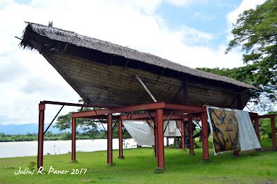
Balangay Building Site. Over at Barangay Bading is the building site of the replica of Balangay (Masawa Hong Butuan) which is also being displayed in the area for public viewing opposite the Agusan River.

Truly, the pre-historic Balangay boat has become a critical identity of Butuan City and it reaffirmed the fact that Butuan Bay was an integral part to the navigational circuit of the ancient times in the Philippines.

Footnote. For visiting guests, do not leave Butuan without dining in D’ Homemakers Café located along the Davao-Butuan highway in Barangay Ampayon. This hygienic restaurant offers mouth-watering dishes, all designed for Pinoy taste buds. They have variety of lutong-bahay dishes such as pinakbet, paksiw na isda, tinolang bisaya nga manok, tinolang isda to name a few. They also have local desserts that could be a good pasalubong item or an instant snack rations to satisfy your hunger in long travels.
Overnight Accommodation. Red Palm Suites is a fair option. It is located in Villa Kananga Road, Butuan City. The swampy nature of Butuan might have caused obnoxious odor to the water system of Red Palm suite, but overall it can be a good alternative.